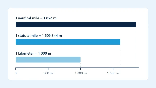
Two different units share the word “mile”. The statute mile is the one on road signs in the United States and the United Kingdom. The nautical mile is the one used for navigation at sea and in the air. A nautical mile is about 15% longer, and treating one as the other puts every distance, speed and time estimate off by the same proportion.
Two miles with different origins
The statute mile is a land measure built from older English units and fixed by law, which is where the name comes from. It contains 5,280 ft.
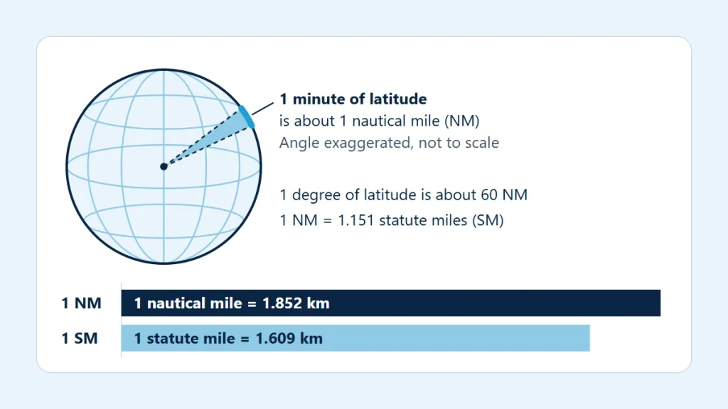
The nautical mile comes from the shape of the Earth. Latitude is measured in degrees north or south of the equator, and each degree is divided into 60 minutes. Historically the nautical mile was the distance along a meridian covered by one minute of latitude. The diagram at the top of this page shows the idea, with the angle greatly exaggerated.
The Earth is slightly flattened, so a minute of latitude is a little shorter near the equator than near the poles. A unit cannot vary with location, so the nautical mile is now defined as a fixed length that is close to the average: exactly 1,852 m. The link to latitude survives as a very good approximation, not as the definition.
The exact definitions
Both miles are defined exactly in meters, so conversions between them involve no measurement uncertainty, only rounding of the displayed digits.
| Unit | Meters | Feet | Nautical miles | Statute miles |
|---|---|---|---|---|
| 1 nautical mile (NM) | 1,852 (exact) | 6,076.115 | 1 | 1.150779 |
| 1 statute mile (SM) | 1,609.344 (exact) | 5,280 (exact) | 0.8689762 | 1 |
| 1 kilometer (km) | 1,000 | 3,280.84 | 0.5399568 | 0.6213712 |
The conversion between the two miles is the ratio of their definitions:
Statute miles = nautical miles × 1,852 ÷ 1,609.344
Nautical miles = statute miles × 1,609.344 ÷ 1,852
Why navigation uses the nautical mile
Because one minute of latitude is about one nautical mile, one degree of latitude is about 60 NM. That turns the chart into its own ruler. The latitude scale printed along a meridian can be used to measure distance directly, and two points on the same meridian that are 2° of latitude apart are about 120 NM apart with no further calculation.
This works for latitude only. Meridians converge toward the poles, so a minute of longitude equals about one nautical mile at the equator and shrinks steadily to nothing at the poles. Measuring distance on the longitude scale is a classic chart error.
The same relationship ties angles to distances across navigation as a whole, which is why the nautical mile remains the standard distance unit on aeronautical charts and in flight planning. Aviation distance units explained looks at how it sits alongside feet, meters and kilometers.
Knots follow from nautical miles
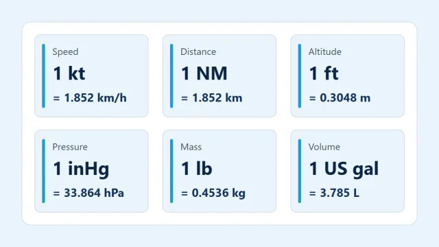
A knot is one nautical mile per hour, so the two speed units differ by exactly the same factor as the two miles: 1 kt is 1.150779 mph and 1.852 km/h. At 120 kt an aircraft covers 120 NM in an hour, or 2 NM per minute, which keeps time and distance arithmetic simple when everything is in nautical units.
Some airspeed indicators, mostly in older light aircraft, are marked in miles per hour, and some carry both scales. Reading one scale and calculating with the other is the speed version of the same mix-up: 120 mph is only 104.3 kt.
A conversion worked through
Suppose a leg measures 250 NM on a chart and you want it in the other two units. The values are an illustration.
- Convert to meters with the exact definition: 250 × 1,852 = 463,000 m.
- Kilometers: 463,000 ÷ 1,000 = 463 km.
- Statute miles: 463,000 ÷ 1,609.344 = 287.6949, about 288 SM.
Going the other way, 100 SM is 86.89762 NM, about 87 NM. The nautical miles to kilometers calculator accepts a distance in nautical miles, kilometers, statute miles, meters or feet and shows it in all the others, using these same definitions.
Two mental shortcuts are common, and both are approximations. Adding 15% to a nautical figure gives statute miles: 250 NM plus 15% is 287.5 SM, against the exact 287.69. Doubling a nautical figure and taking off a little gives kilometers, since 1 NM is 1.852 km. Use them to check that a result is plausible, and use the exact factors for the result itself.
Where statute miles still turn up
Aviation has not dropped the statute mile completely, and the places it survives are where confusion starts:
- Visibility. Weather reports in the United States give visibility in statute miles, while most other countries report it in meters or kilometers.
- Older instruments and manuals. Some aircraft documentation lists speeds in mph, and speeds must be read in the unit the document uses.
- Everyday sources. Road maps, mapping apps and general reference material quote statute miles or kilometers, so a distance taken from them is not a nautical figure.
The habit that prevents errors is to write the unit next to every number, NM or SM and kt or mph, and to convert once at the start instead of partway through a calculation. The aviation unit conversion calculator covers the speed conversions, and essential aviation unit conversions collects the other factors worth knowing.
What a unit conversion cannot do
Converting a distance changes its unit, not its accuracy. The “one minute of latitude” relationship is approximate because the Earth is not a perfect sphere, and a distance scaled off a chart depends on the chart’s projection and on how carefully it was measured. The shortest distance between two distant points is a great-circle arc, which the flight distance calculator estimates on a spherical Earth; a route actually flown is longer, because it follows airways, procedures and airspace.
For real flight planning, take distances from current official charts and navigation data, speeds in the units used by the aircraft flight manual (POH/AFM), and visibility and other minimums from the applicable regulations in the units they specify.