A pressure altimeter does not measure height. It measures the pressure of the air outside the aircraft and converts it to an altitude using the fixed pressure-to-height relationship of the standard atmosphere. The altimeter setting is the adjustment that tells the instrument which pressure to treat as zero.
The setting matters because the atmosphere does not hold still. Sea-level pressure rises and falls with the weather, and without a correction the same aircraft parked on the same ramp would show a different altitude from one day to the next.
What the setting knob does
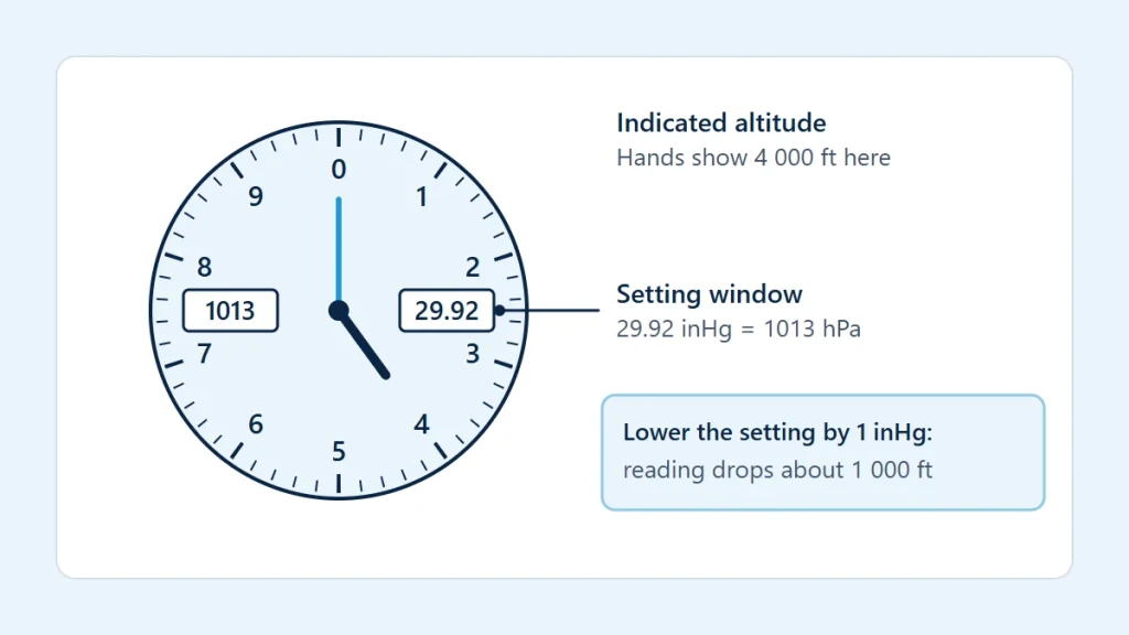
The setting window on the instrument face, shown in the diagram at the top of this page, displays a pressure in inches of mercury or hectopascals. Turning the knob changes that reference pressure and moves the hands with it. The instrument then shows the standard-atmosphere height difference between the reference pressure in the window and the pressure it senses outside.
Two consequences follow. Raising the setting raises the indicated altitude, and lowering it lowers the indication, with the aircraft not moving at all. And the altimeter is only as correct as the match between the number in the window and the real pressure situation.
The settings in use
| Setting | What is put in the window | What the altimeter then shows |
|---|---|---|
| QNH (the local altimeter setting) | The station pressure reduced to mean sea level using the standard atmosphere | Altitude above mean sea level; on the ground at that airfield, the field elevation |
| Standard setting | 1013.25 hPa or 29.92 inHg, whatever the weather | Pressure altitude, which is reported as a flight level at higher altitudes |
| QFE | The pressure at the airfield itself | Height above that airfield; zero on the ground there |
QNH is the setting used near the ground, because charts give terrain, obstacle and airfield elevations above mean sea level. In the United States it is simply called the altimeter setting. The standard setting is used higher up, where separation between aircraft matters more than the exact distance to terrain: if every aircraft uses the same reference, they stay vertically separated even though none of them shows true height. Understanding Pressure Altitude explains what the standard setting displays. QFE is used in some countries and by some operators and not at all in others.
The altitude at which crews change from the local setting to the standard setting in a climb, and the level at which they change back in a descent, are not universal values. They are set by each country and can differ by airspace and even by airport, and in some places the level used in the descent varies with the pressure of the day. They are published in official aeronautical information and on charts.
Inches of mercury and hectopascals
Altimeter settings are given in inches of mercury in the United States and a few other countries, and in hectopascals in most of the world. A hectopascal is the same size as a millibar. The conversion uses 1 inHg = 3,386.389 Pa, which is 33.86389 hPa:
hPa = inHg × 33.86389
The standard setting is 1013.25 hPa, 29.92 inHg or 760.0 mmHg. A few conversions from the altimeter pressure conversion calculator: 30.10 inHg is 1,019.3 hPa, 29.42 inHg is 996.3 hPa, 1020 hPa is 30.12 inHg and 995 hPa is 29.38 inHg.
The two scales produce numbers that cannot be confused once you know the range: settings in inches cluster around 30 and settings in hectopascals around 1,000. Errors happen within a scale, for example 29.92 set in place of 28.92. That mistake is worth about 1,000 ft.
How much altitude a setting change is worth
The usual approximations are 1,000 ft per inch of mercury and about 27 to 30 ft per hectopascal near sea level. They are rules of thumb. The exact value comes from the standard-atmosphere relationship between pressure and height:
h (ft) = 145,442.16 × [1 − (P ÷ 1013.25)0.190263], with P in hPa
Evaluating that with the pressure altitude calculator gives 939 ft for the inch from 29.92 down to 28.92 inHg and 911 ft for the inch from 29.92 up to 30.92 inHg. One hectopascal next to the standard value is worth 27 ft, and ten hectopascals below it are worth 274 ft.
Flying toward lower pressure with an old setting
Consider this illustration. An altimeter is set to 1020 hPa, the correct local setting at departure. The aircraft then flies into an area where the local setting is 995 hPa, and the setting is not updated.
- The standard-atmosphere altitude of 1020 hPa is −184 ft.
- The standard-atmosphere altitude of 995 hPa is 502 ft.
- The reference in the window is therefore 686 ft lower than it should be, and the altimeter reads 686 ft too high.
An aircraft holding a constant indicated altitude through that change has in fact descended by 686 ft relative to sea level. The 27 ft per hectopascal approximation gives 675 ft for the same 25 hPa difference, which is close but not the same. The error works in the other direction when flying toward higher pressure: the altimeter then reads too low. The first case is the hazardous one, because the aircraft is lower than its instrument says.
What a correct setting still does not fix
The altimeter assumes that the air between the reference level and the aircraft has standard temperature. When the air is colder than standard it is denser and the pressure levels are packed closer together, so the aircraft is lower than the altimeter indicates. In warmer air it is higher. The error grows with height above the station that issued the setting and with the size of the temperature difference, and no setting removes it. The International Standard Atmosphere article describes the temperature profile the instrument takes for granted.
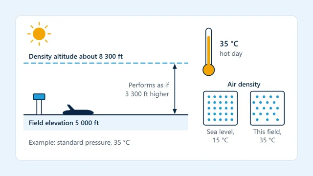
The same non-standard temperature is the reason indicated altitude and density altitude are different quantities. One tells you where you are relative to charted elevations; the other describes how thin the air is.
Altimeters also have mechanical and installation errors, and a setting is valid only near the station that reported it and near the time it was issued.
Limits of this explanation
This article describes the principle, not a procedure. Which setting to use, where to change it, how often to update it, the allowed altimeter error and any cold-temperature corrections are all defined by the applicable regulations and the published procedures for the airspace being flown. Altimeter settings come from current official weather reports or air traffic services, never from a calculation, and terrain clearance is planned with current official charts and the aircraft flight manual (POH/AFM).